
The radar beam appears to be striking at or near the grounds at the other high school
You can right-click and “Open image in new tab” to view any of these slides full-screen
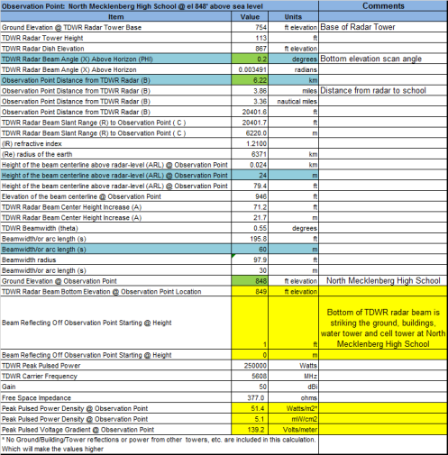
The recent publicly released geospatial study of the ocular melanoma cancer cluster in North Carolina was overlayed in Google Earth. The “hotspot” identified near North Mecklenburg High School is the highest elevation in the local area at 848 ft above sea level and there is a water tower located beside the school to take advantage of the elevation. My TDWR beamwidth calculations were updated using a USGS topographical map of the area to verify elevations and distance from the TDWR radar to the school. Because the school grounds are almost 100 ft above the base of the pulsed radar station, the Charlotte TDWR radar beam appears to be striking the North Mecklenberg High School grounds every low elevation scan. A discrepancy was discovered on the terrain elevation of the Charlotte radar station reported on this website This should be verified as I believe the terrain elevation is 754′ max and the website says 807′. Exposure to EMF should be higher at higher elevations from all sources due to less blockage and a direct path/fresnel zone.


