

These are Philippine Fish, Not from Hawaii…
From Terry Lilley, Marine Biologist, Kauai
I just spent the week in Oahu filming the Pipe Masters surf contest and that was a blast! But yesterday I did something much more important. For a National Geographic TV special I shot video of the dying corals in Kaneohe Bay Oahu that are right under the Military Base and Microwave towers! This bay is just devistated. Filled with diseased and dying corals. I also shot a different National Geographic TV special in Kauai last month and shot video of our ruined coral reefs in Kauai. Both of these TV shows will bring this disaster to the world in the spring! When I arrived back in Kauai last night I found this magazine at the airport advertising our coral reefs. But something is VERY wrong. The picture on the cover is a beautiful Philippine coral reef with Philippine Panda Butterflyfish! We are loosing our reefs so fast that even the tour companies have to use pictures for outside of Kauai to keep their business. This is just a major wake up call for the people of Hawaii as we will soon loose our tourist business if we do not wake up, fund coral reef studies and try to fix what is killing the reefs! Here are some picks of our “real” reefs in Kauai so they would not look so good on the front cover of this tourist magazine! Has anyone ever heard of false advertising?
Now for a real dissolving Coral Reef in Kauai!

Holy Shit, that was a hard coral!

Rare, Self-Precipitating Kauai Coral. Only found near radar stations
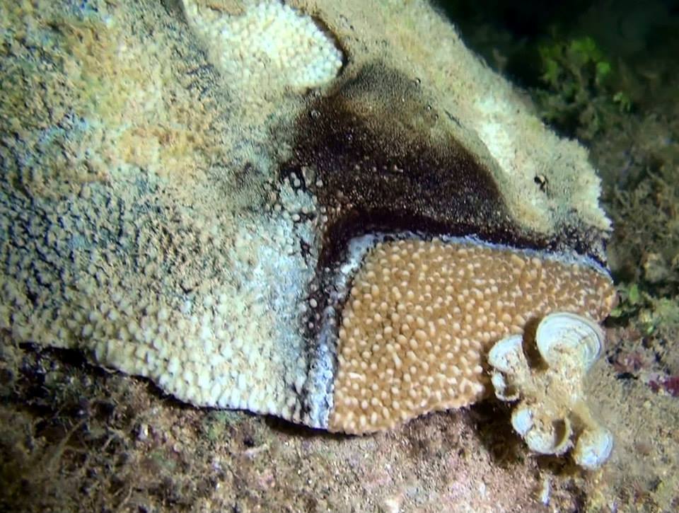 This is what 30,000,000 plus pulsed watts of electromagnetic radiation does when it hits the surface of the ocean 1000 times per second 24/7. No wonder our kids can’t breathe and are getting leukemia.

Scatter and Doppler Effect of Wind Power Plants to Land Radars
“Abstract—Wind power plant installations at different scales are in an increasing pattern starting from year 2000. A curiosity has been raised about 4-5 years ago for if wind turbines interfere with radars. The interference occurs when wind turbines reflect radar waves and cause missing targets and blind regions on radar images. Doppler radars are most used to discriminate between the return from a desired target and that from undesired objects, usually ground clutter [1]. There are so many resulting effects of interference such as shadowing, damage to radar equipment, larger radar cross section (RCS) and missing desired targets, etc. Both radar and wind power plant mitigations are available. But still, there is no overall solution, only case by case treatment. RADAR is an acronym for RAdio Detection And Ranging, it will be used as “radar” throughout this paper.”
If the extra reflected radiation from the turbine blades is damaging the radar equipment, WHAT IS IT DOING TO YOU AND YOUR CHILDREN?
‘Wind Turbine Syndrome’ Blamed for Mysterious Symptoms in Cape Cod Town
“Sue Hobart, a bridal florist from Massachusetts, couldn’t understand why she suddenly developed headaches, ringing in her ears, insomnia and dizziness to the point of falling “flat on my face” in the driveway.”I thought I was just getting older and tired,” said the 57-year-old from Falmouth.Months earlier, in the summer of 2010, three wind turbines had been erected in her town, one of which runs around the clock, 1,600 feet from her home.”

Electromagnetic Power Density Around High Powered, Pulsed Phased Array Radar on Cape Cod. Actual diameter and power density of non-isotropic band of radiation refracting off atmosphere and reaching the ground will vary with radar pulse angle off horizon and cloud ceiling.
You are irradiating your children

The red shaded area is the highest pulsed electromagnetic radiation power density striking the ground from non-isotropic radars refracting off overhead atmosphere. Highest refraction will be during fog/low cloud ceiling as well as off low flying overhead aircraft.

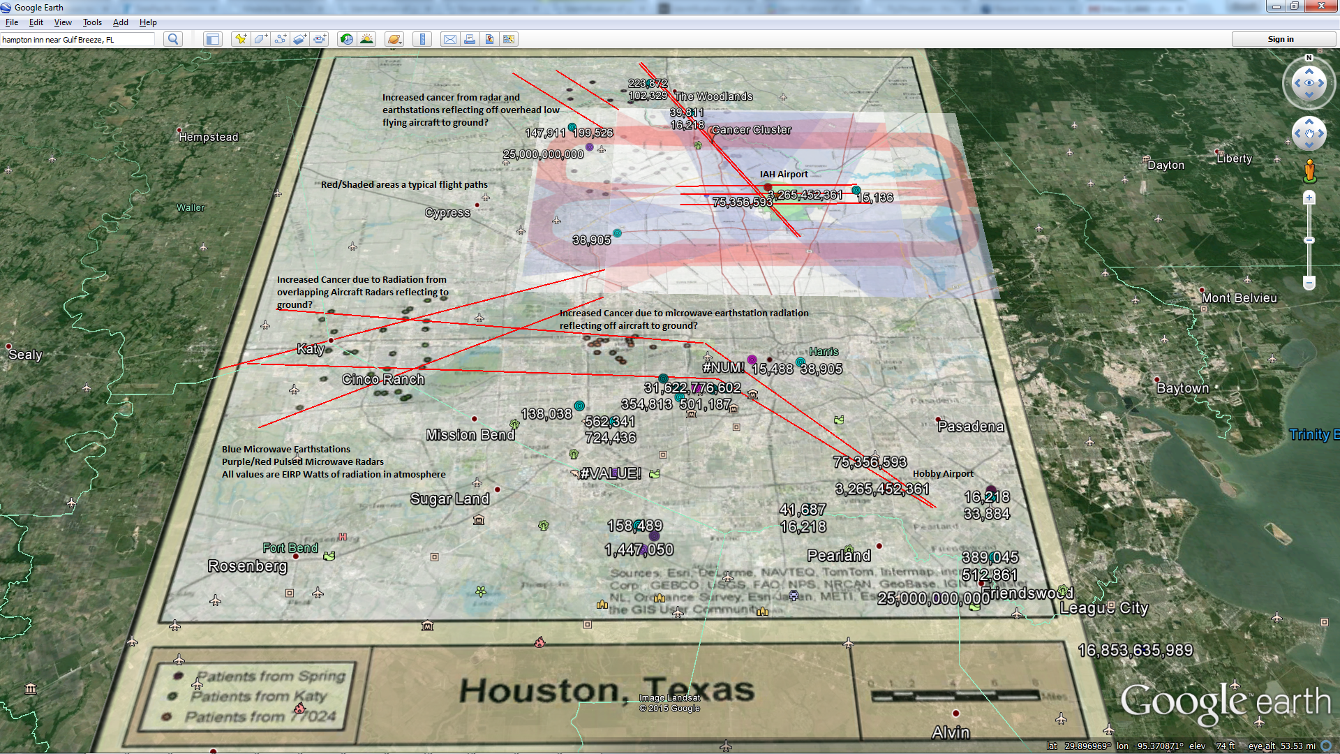
That is a boatload of high power, high gain, pulsed microwave radars crossing the flight paths over Woburn, Mass with very high reflected pulsed power densities.
Toms River, Woburn, and the sad lack of clean answers about ‘Cancer Clusters’
“- I can still hear the sadness in the voices of Anne Anderson and Donna Robbins and Mary Toomey and the other parents inWoburn who believed industrial solvents in the town’s water had killed their kids…more than a dozen kids dead of leukemia in just their one small neighborhood.
– I recall the courage of the parents of autistic kids in Leominster, who suspected that the unusually high prevalence of autism in their area was caused by the plastic industry’s activity there years before.
– I remember the conviction among the parents in Lowell that the industrial chemicals oozing from those rusted barrels on the Silresim hazardous waste site had caused the concentration of respiratory problems (from reflected EMF) in the neighborhood, in kids and adults.
And I remember the universal anger these people felt about what had been done to them, because certainly, they felt, so much similar illness in such a small area could not be a matter of chance alone. I remember their fierce certainty that the unusual cluster of illness and death had to be somebody’s fault, and their powerful need for research to confirm their belief that pollution had poisoned their kids. That confirmation never really came.”
LONG-TERM EXPOSURE TO MICROWAVE RADIATION PROVOKES CANCER GROWTH: EVIDENCES FROM RADARS AND MOBILE COMMUNICATION SYSTEMS
Epidemiologic evidence relevant to radar (microwave) effects.
STOP THE FLIGHT PATH OVER WOBURN NEIGHBORHOODS!!
JET PLANES ARE OBSTRUCTION OF LIVING HERE
(Low Flights = High Microwave Reflection to Ground from Radars bouncing off Planes!)
Disclaimer: I might be right or I might be crazy. I will let you decide.
What if our first contact from other intelligence was warning us about the way we were communicating to them and our use of RF and Microwaves?

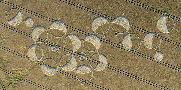
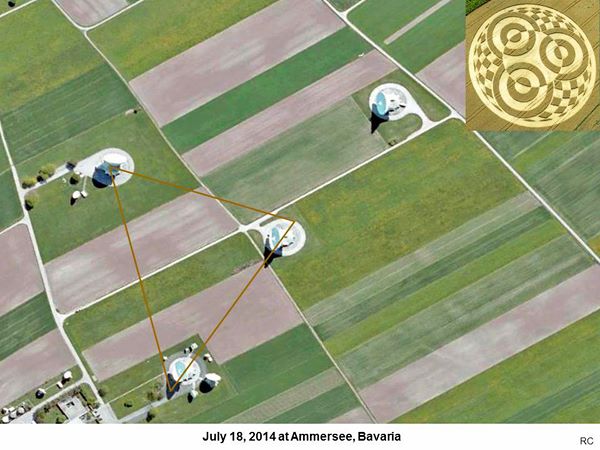
FYI, those radar stations are not just passive listeners, they are high powered, pulsed microwave transmitters. This graphic was put together by “Red Collie” a crop circle researcher. Source: http://www.cropcircleconnector.com/anasazi/fringe2014t.html
Superposition of Electromagnetic Radiation

Crop Circles Pointing to Airport Radars

Warning us of high powered electromagnetic RF & Microwave Transmitters.


What Then?

Increased Male Lung Cancers appear to be clustered around high power, high gain pulsed microwave radar towers
All Cancer Mapping Data is from the following research study. Full credit to the authors.
Local clustering in breast, lung and colorectal cancer in Long Island, New York.
High Power Pulsed Microwave Radar Locations (Google Earth KML)

Increased Female Lung Cancers appear to be clustered around high power, high gain pulsed microwave radar towers

Female Breast Cancer Clusters. I added Active Airport Runway approach paths(red X’s) because my other maps are implying the additional reflection of pulsed radar microwaves off low flying airplanes are possibly the areas of highest disease due to increased, chronic EMF. The San Francisco area also has lots of airport runways and aircraft in areas of increased breast cancers.
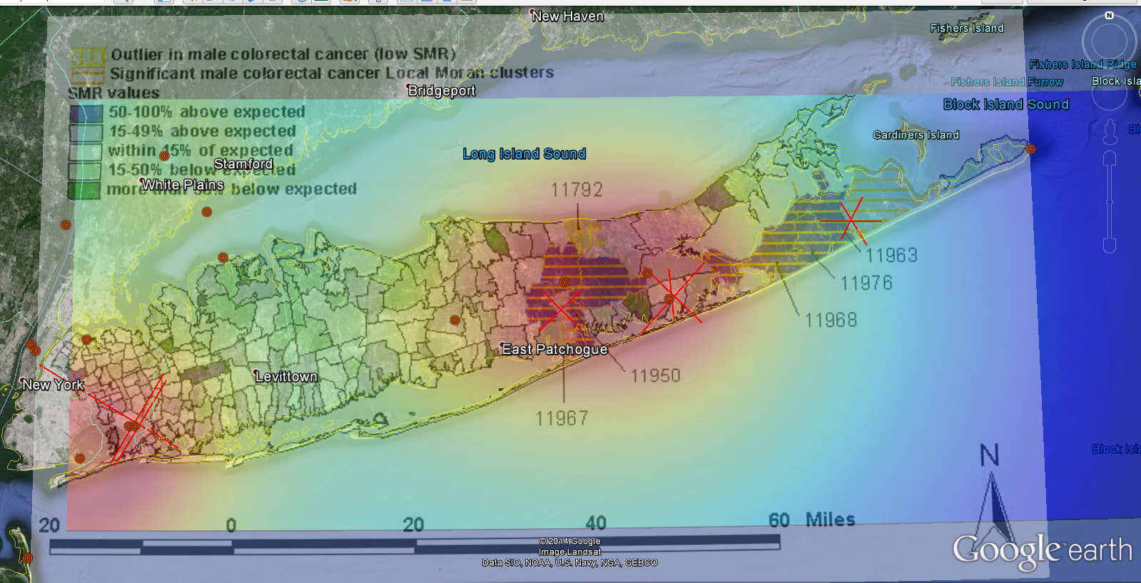
Male Collorectal Cancer

Acreage Cancer Cluster also fits well between the flight paths of PBI airport flights. Reflection off airplane bodies from high gain pulsed radars in the area will strike surrounding Earth with very high pulsed power.


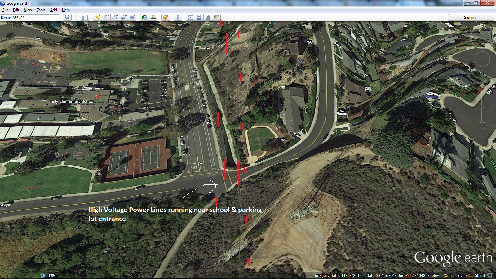
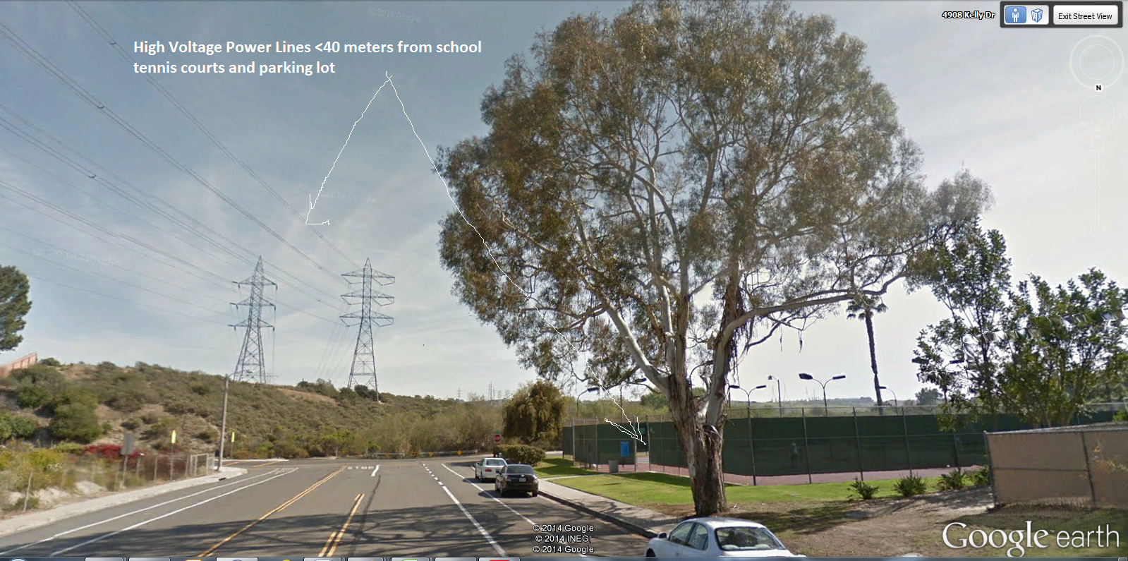
This is the 2nd school with a cancer cluster with high voltage power lines running less than 40 meters from the tennis courts and fields
Possible Cancer Cluster in Carlsbad Under Investigation
Stacey and John Quartarone of Carlsbad, Calif., lost son Chase, 16, to non-Hodgkins lymphoma in December. A dying wish was for his parents to find out what caused his cancer. “He said, ‘Please don’t let anybody else get this,'” mom Stacey Quartarone said.The Quartarones are doing their best to honor their son’s wish. They’ve done their research and have discovered others in Carlsbad who said they have cancer or whose family members developed it. But what started as a quest to determine Chase’s cause of death led them to what they believe is a so-called cancer cluster around Kelly Elementary School, which their son had attended “There were at least 15 confirmed cases of cancer in the last 15 years,” Stacey Quartarone said. “We’re positive that at least eight teachers have had different types of cancer in the last 10 years.”
The Quartarones and others who believe something environmental is behind what they describe as an abnormally high number of cancer cases in Carlsbad pushed the school district earlier this year to perform soil testing.
Must have been a stupid ass electrical engineer or civil engineer that ran them through the middle of town beside a school.
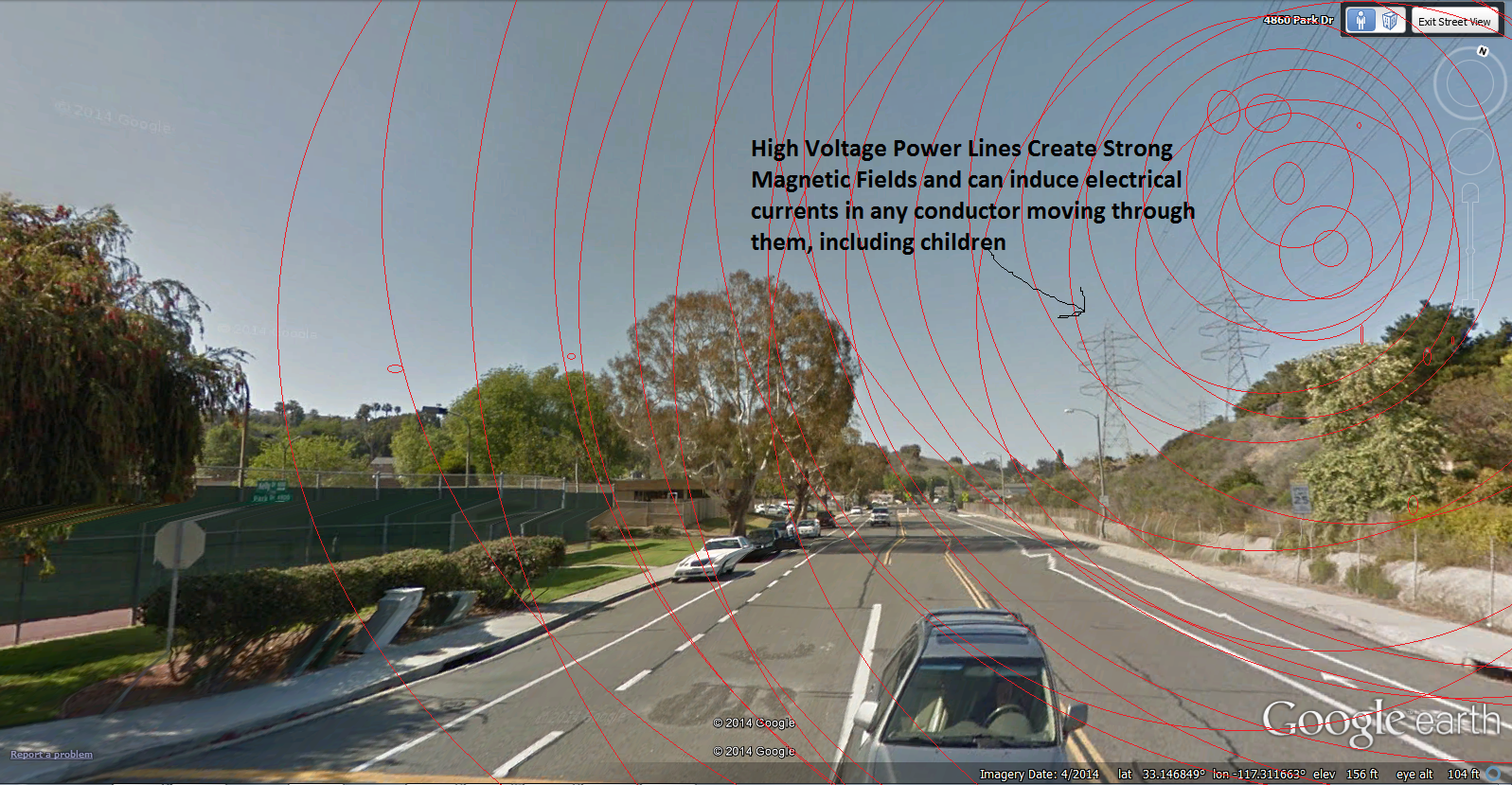
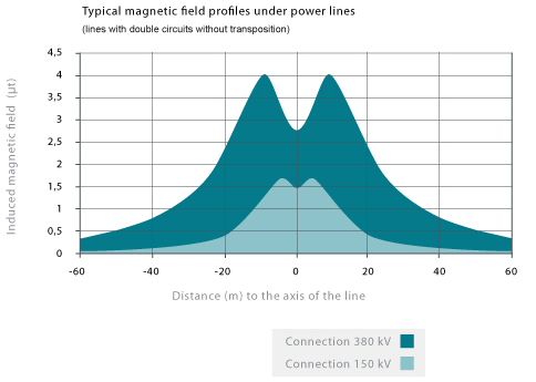
Strong Magnetic Fields around High Voltage Lines.
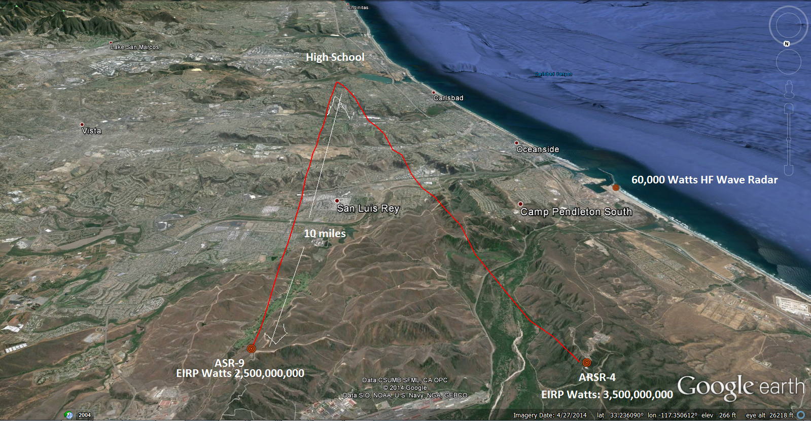
They also have two of my favorite high power, high gain pulsed microwave radars within 10 miles of the school that refract and duct off the overhead atmosphere and authorities don’t have a clue where all of the radiation goes.
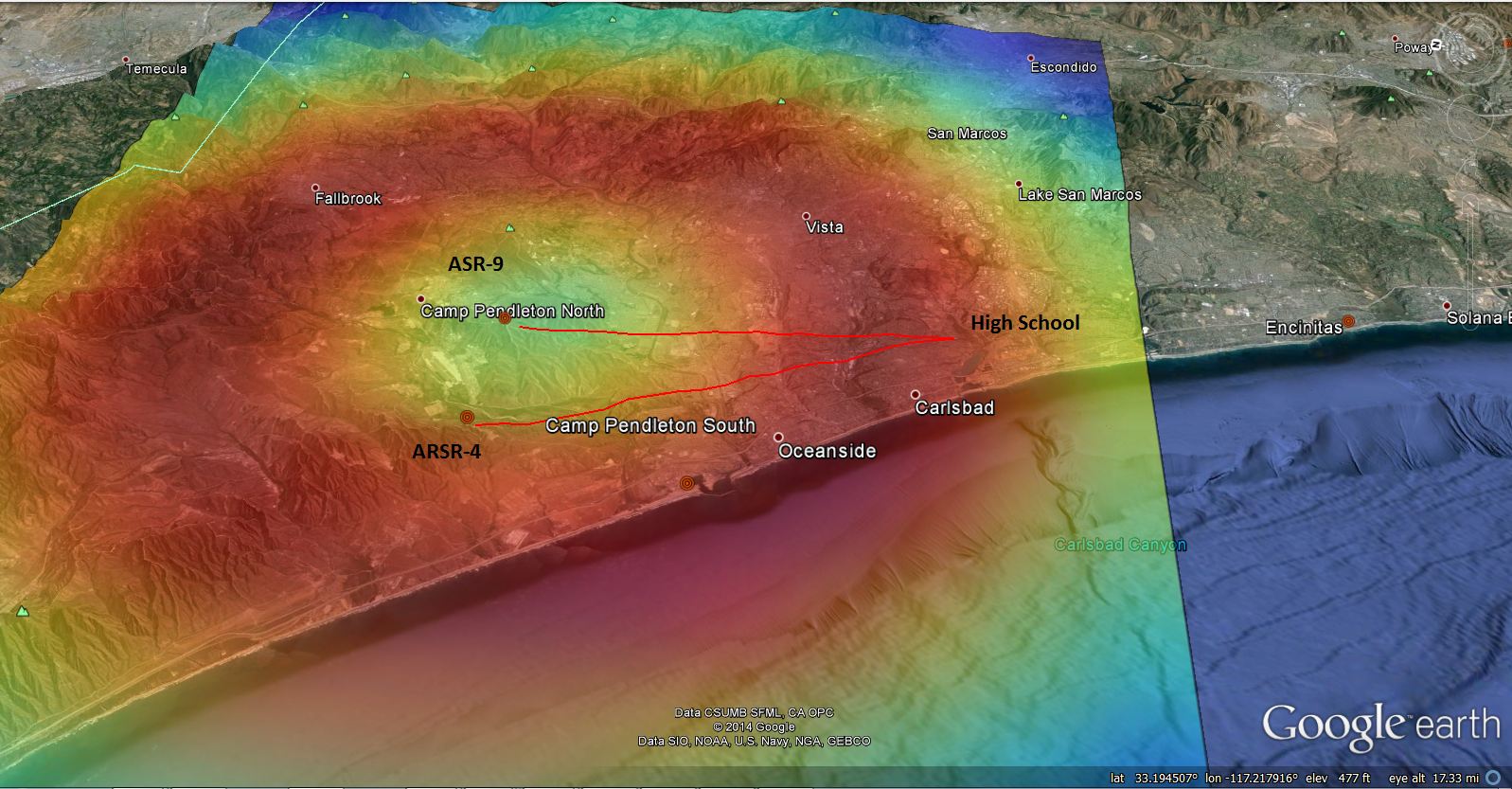
That 10-15 mile ring you see around the radars is due to the “cone of silence” since the radars are typically pointed 0.5-60 degrees angle off horizontal. The scattered radiation reaching the ground can be 3-4 times the power level making it back to the dish. The diameter of that ring will vary with cloud ceiling and radar angles. Red areas get the highest flux/power density of radiation to the ground/ocean.


