

To Remove Unsightly BioFilm And BioContaminant Buildup
Please use a strong, pulsed, oscillating ElectroMagnetic Field, Like This

Low Frequency Pulsed Electromagnetic Fields Do a Pretty Good Job Breaking up Ca++ and Mg++ compounds
Which is known to remove unsightly biofilms, such as those found in the ocean, based upon this study
Electromagnetic field (EMF) treatment is presented as an alternative physical treatment for the mitigation of biofouling adhered to the tubes of a heat exchanger-condenser cooled by seawater. During an experimental phase, a fouling biofilm was allowed to grow until experimental variables indicated that its growth had stabilised. Subsequently, EMF treatment was applied to seawater to eliminate the biofilm and to maintain the achieved cleanliness. The results showed that EMFs precipitated ions dissolved in the seawater. As a consequence of the application of EMFs, erosion altered the intermolecular bonding of extracellular polymers, causing the destruction of the biofilm matrix and its detachment from the inner surface of the heat exchanger-condenser tubes. This detachment led to the partial removal of a mature biofilm and a partial recovery of the efficiency lost in the heat transfer process by using a physical treatment that is harmless to the marine environment.
Here is a pdf of a study report here
“…is effective for any dissolved inorganic ions including calcium,
magnesium, barium, silica, bicarbonate, sulphate etc.”
My research indicates you can even use low frequency (200-1000 Hz pulses) of GHz radiation from radars


Repeat 1000 times/second forever. Do this for long enough, at high radiated power (~30,000,000 pulsed overhead watts in Kauai – ~ 299,999,824,045 EIRP @ 40dB) appears to be MORE than plenty!), and

Unsightly BioFilm And BioContaminants ALL REMOVED! Hooray! Can’t you see all of the PRECIPITANT from the seawater!
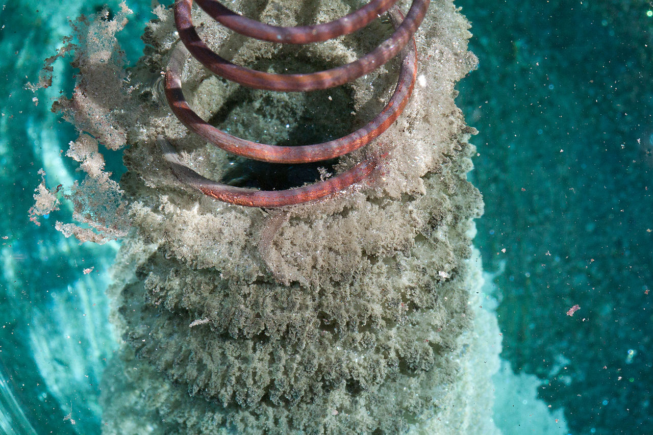
This is what precipitant looks like!
You will have disassociated most of nature’s unsightly biofilms, including those made of Calcium compounds, Magnesium, silica and included in most biologically active lifeforms. These are all considered “Boilogical Contaminants” by the radar dumbass engineers
Uh, Houston, we have just drifted through a patch of strong electromagnetic discharge and I think we have sustained permanent damage to the nose, tail fin and ailerons.
———- Forwarded message ———-
From: underwater2web . <underwater2web@gmail.com>
Date: Sun, Oct 5, 2014 at 11:40 AM
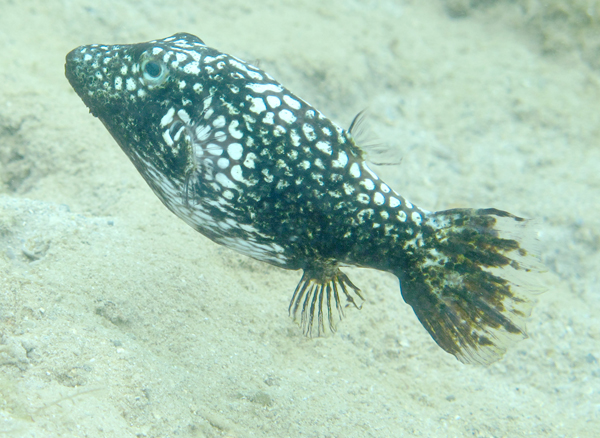
Subject: Toby Fish with rotting fins vs Military Electronic warfare!!
To: ChemE Stewart <cheme911@gmail.com>
Cc: Whomever you are from wherever you are
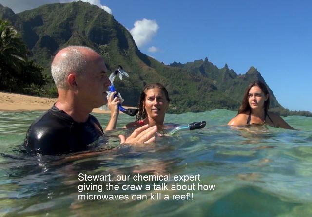
Hi Stewart,

Uh dudes, remember me? I used to look like this.
Lets try to get you together with the Garden Island News while you are here on Kauai so we can update them on your discoveries about the dissolving corals and how this can happen due to the military high powered pulsing microwave towers!!
Terry
From: ChemE Stewart <cheme911@gmail.com>
Date: Wed, Oct 15, 2014 at 12:35 PM
Subject: Re: Toby Fish with rotting fins vs Military Electronic warfare!!
To: “underwater2web .” <underwater2web@gmail.com>
Terry,
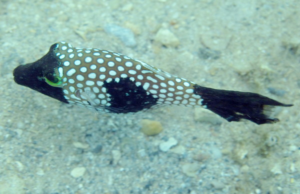
Help! I used to be all spotted!
The electrons are moving along the surface of the fish and discharging along his pointed surfaces, which are his nose, fins and tail, same as an airplane’s electrostatic wing discharge and also the diseased areas on the dorsal fins of dolphins and possibly the digits of those sea turtles. Along the areas of the fish where the radius is smaller, the current density and flow will be higher. He suffers from the fact he has a pointed face/nose area. Similar issues around the 17,000,000 watts of pulsed radars in the Indian River Lagoon, FL.

What if you are standing on the ground where that pulse is going?
http://www.ntia.doc.gov/files/ntia/publications/compendium/2700.00-2900.00_01MAR14-1.pdf
Page 10
“The peak power of the NEXRAD is 1 Megawatt (1×10⁶ Watts) and it employs a directional antenna
with a mainbeam gain of 45 dBi; resulting in a transmitted signal power level of 32 Gigawatts”
How do we know the path of the beam all times?
Aside from when AP is seen on the radar, we don’t! To know the path of the beam would require us to know the exact composition of the moisture, temperature and pressure in the atmosphere, up to 70,000 feet, every minute or so, within about 240 miles of the radar and that capability does not exist.

If I didn’t know better I would think that was a Shark Turd
Sea Surface Climate Change Says One Scientist!
“LIHUE — Scientists say higher-than-normal sea surface temperatures are threatening corals around Kauai.”
(Things must be cooler around the Big Island, closer to the equator, corals look good!)

Guilty as Charged?
The MOON says another scientist!
“LIHUE, Hawaii (AP) — A Kauai scientist says the recent full moon and extreme tides may have contributed to coral bleaching off the Kauai coast.”
(My second guess was Jupiter. What do they smoke on Kauai?)

If I didn’t know better I would think that was a Whale Turd – I had more hair when I started that dive.
It’s the Military Industrial Complex (RADARS) says a 50 year old chemical engineer with a blog, bad jokes and some pretty damn good music.
(30,000,000 Pulsed Watts x Hi Gain (~40 dBi) = ~JigaWatt EIRP of overlapping focused radiation bouncing everywhere – see my scattered, smothered and covered theory)
http://www.ntia.doc.gov/files/ntia/publications/compendium/2700.00-2900.00_01MAR14-1.pdf
The peak power of the NEXRAD is 1 Megawatt (1x10e6 Watts) and it employs a directional antenna
with a mainbeam gain of 45 dBi; resulting in a transmitted signal power level of 32 Gigawatts (You have rough equivalent of 22 of these on Kauai)

NEXRAD WSR-88
I said don’t laugh
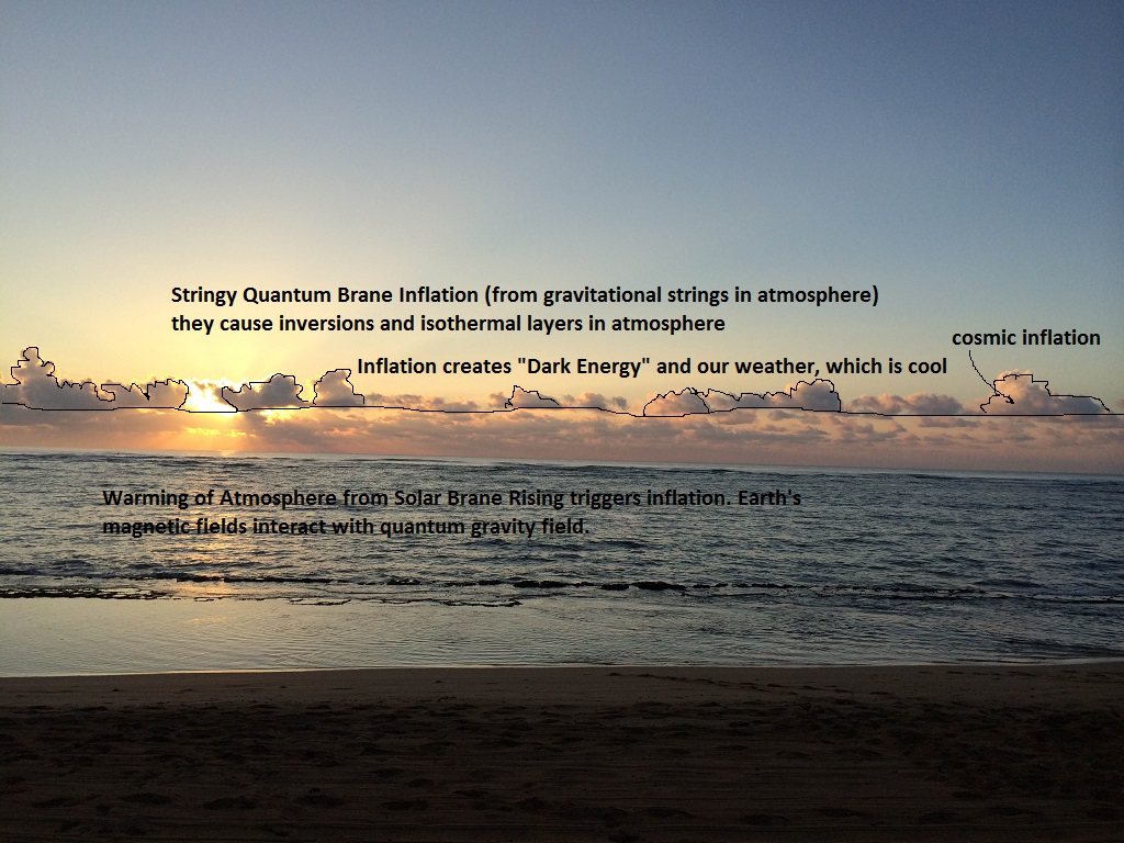
Our atmosphere is full of stringy layers of quantum vacuum at different energy/vacuum levels. They inflate in our atmosphere and create “dark energy”, storms and also some Earthquakes as they warm and interact with Earth’s magnetic fields. That is why our most powerful storms come from “cold fronts”, most likely a BEC, which is bass-ackwards from what you would expect from a gas.
According to the inflationary model, at the critical temperature, spacetime starts to under go this phase transition from one minimum to the other. But it doesn’t do it smoothly, it stays in the old “false” vacuum too long. This is called supercooling. This region of false vacuum expands exponentially fast, and the vacuum energy of this false vacuum is the cosmological constant for the expansion. It is this process that is called Inflation and solves the flatness, horizon and monopole problems. This region of false vacuum expands until bubbles of the new broken symmetry phase with f=f0 form and collide, and eventually end the inflationary phase. The potential energy of the vacuum is converted through to kinetic energy of matter and radiation, and the Universe expands according to the Big Bang model already outlined.

Dissolving Coral?
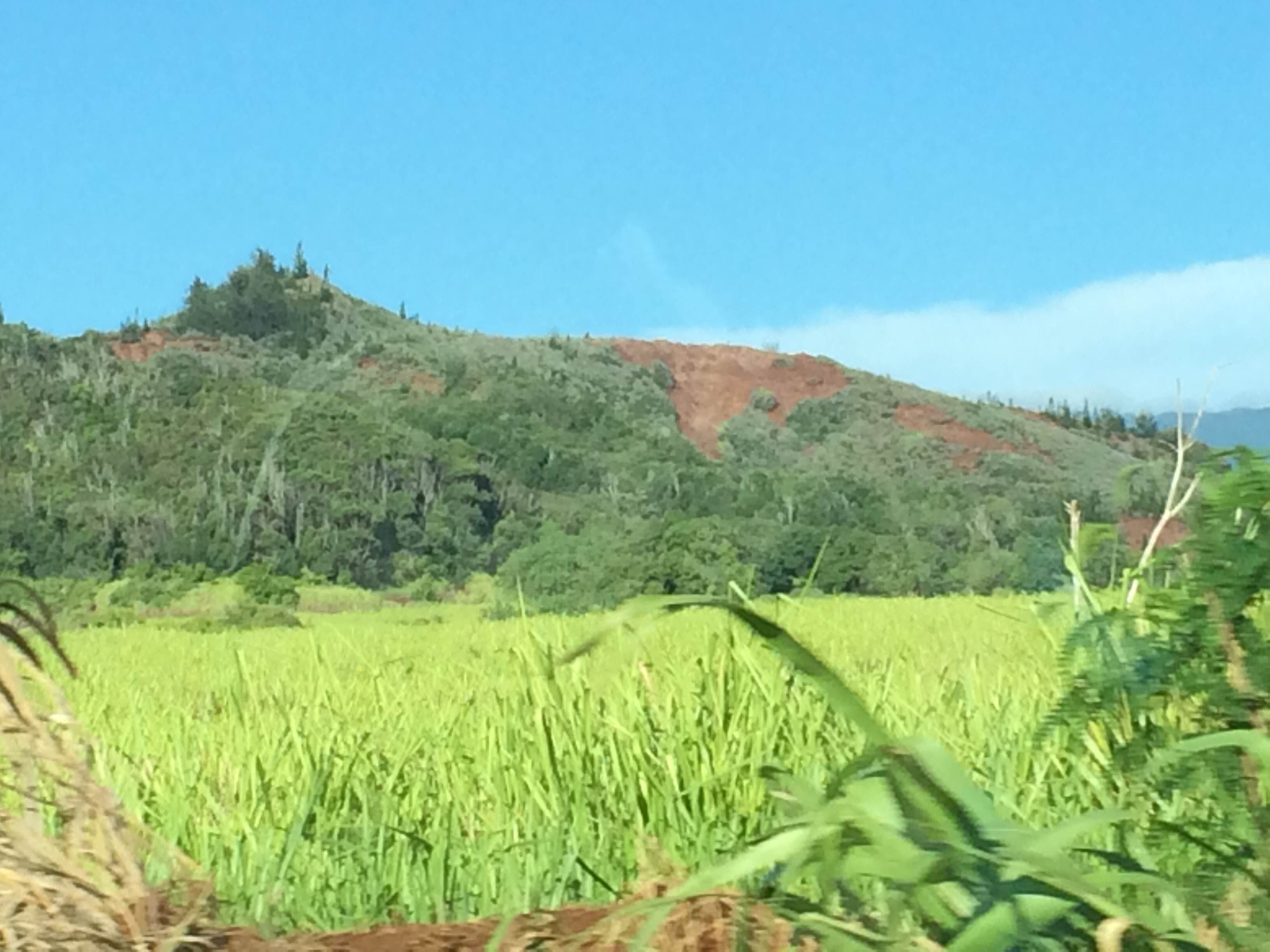
Dissolving Mountain?

Dissolving Beach?
Dissolving Coral?
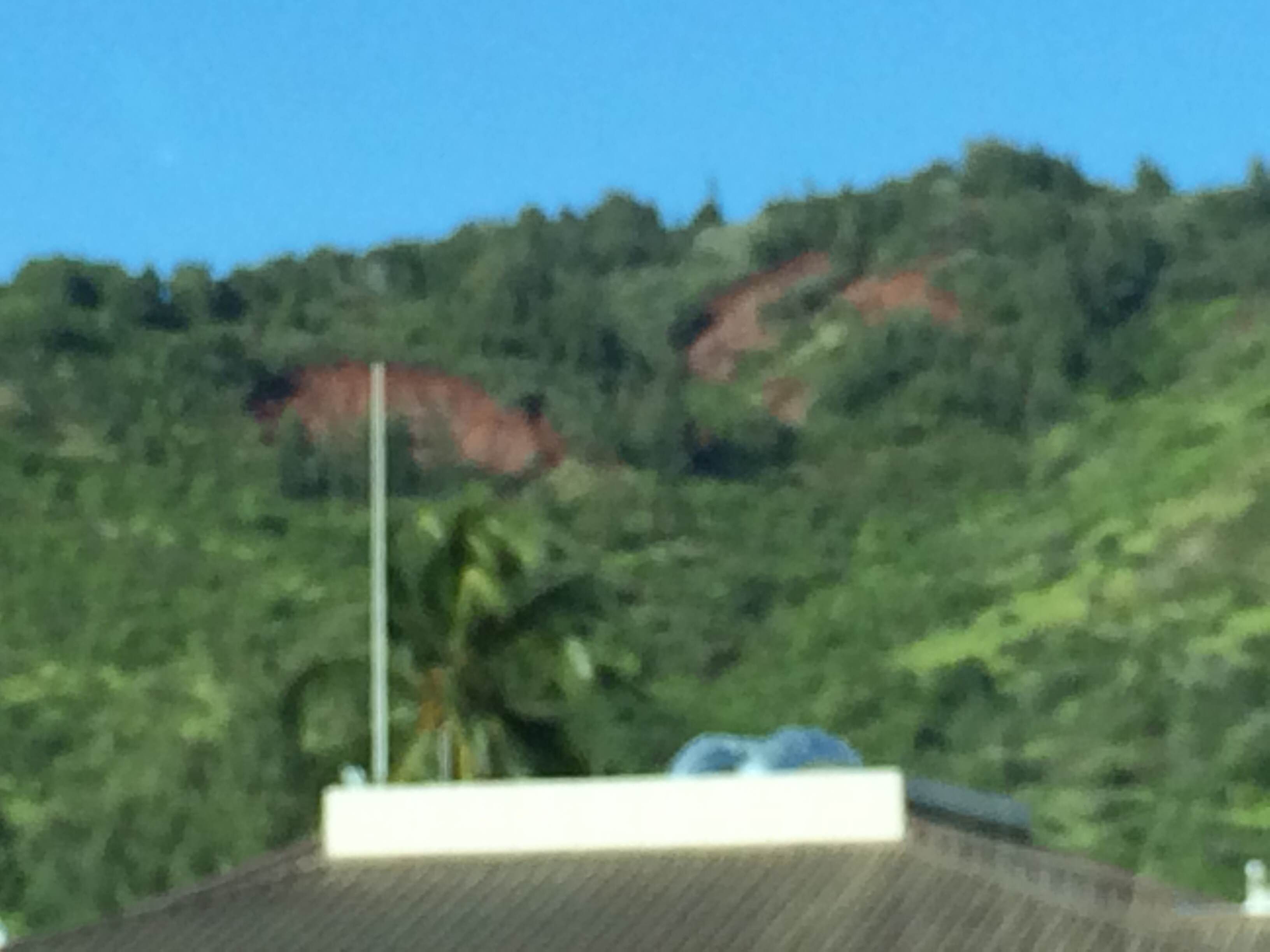
Dissolving Mountain?

Dissolving Beach?

Dissolving Hillsides (Landslides) 2-4 miles from 1,000,000 Pulsed Microwave Radar in addition to the other 30 Million Pulsed watts on the other end of the island?
That’s all, I just noticed everything appeared to be dissolving…

In general, the wild natives were a bit restless but happy to see me… Some crazy “Reef Madness” thing going on…
But the military was too busy to see me…
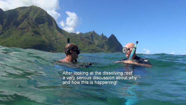
So I did some dives to see for myself how something so beautiful and remote could get so dead underwater…
Trip Report
Kauai, Hawaii Reef Survey
10/4-10/6 2014
Rev B. 10/9/14
This report summarizes my observations of the physical conditions of two of the North shore inner reefs located at Tunnels Beach and Ke’e beach on the Northern most Hawaiian Island of Kauai. Tunnels Beach offers a wide crescent shaped beach and has a very long inner and outer reef, one of the larger in Hawaii. Ke’e Beach is the last beach accessible by car on the on the Western end of the North shore. Located at the end of the road, Ke’e Beach is probably the most visited beach on Kauai.
As a chemical engineer, what interested me most about the North Shore reefs is not just the exceptional amount of coral polyp disease(which is extreme – millions/billions? of dying/diseased coral polyps) but also the fact that in addition to the disease, the entire calcium carbonate skeletons of the coral reef, built up over tens of thousands of years, appears to be decaying, dissolving and/or disassociating very quickly within just a few years back down to lava rock. This implies there may be a strong environmental stressor on the reef since the coral skeleton is not a living entity and calcium carbonate typically makes a very strong and durable structure.
10/4/14 Ke’e Beach
 I met Terry Lilley, a senior marine biologist on the island. Terry dives almost daily on the islands. We discussed the diseased and decaying reef situation. Terry showed me a typical piece of antler coral with the antlers broken off 4-6 inches below the tips of the antlers, which is widespread along the reef. As an engineer it appears to me as a structural failure of the calcium carbonate skeleton, either from a sudden concussion from within the water, such as possibly the recent RIMPAC war games offshore. The other option I will discuss in more detail is that something may be quickly weakening the calcium carbonate coral skeleton structure until the wave action snaps the antlers off at the weakest point with the highest stresses on each antler. Neither option can be ruled out.
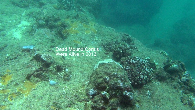
Our snorkel dive along Ke’e beach was very revealing. As we snorkeled along the inner reef it was apparent there was very little sea life such as schools of fish which would typically populate a reef of that size. Also, within the first three feet of seawater, the coral calcium carbonate skeleton appeared almost 100% dissolved and/or disassociated. The top of the reef appeared almost leveled off like a shelf, covered in a mossy green algae. The calcium carbonate structure that remained would just crumble in your hand in places whereas it typically is strong enough to withstand intense wave action. The remaining corals at levels 3 to 20 feet appeared to be 60-90% diseased with brown patches of decay and patches of cyanobacteria disease widespread.. The blue rice corals , which typically cover areas continuously for a few feet in diameter, were broken up and very patchy with dissolved areas in between. The visibility was also low, approx 10 feet with a high visible concentration of suspended solids, probably from the dissolving reef.
One area of Ke’e reef that conspicuously had little coral disease was located to the far west end of the cove and faced East and is shaded by a rock wall, trees and a very large peak behind it. This shaded area appears to get much less visible light/radiation during the day than the other exposed areas of the inner reef further out where the bulk of the disease is located. This area also had schools of fish, which were missing in the other areas. This area had large areas of blue rice and other corals that looked 95-100% healthy
10/5/14 Tunnels Beach
 Our snorkel dive along Tunnels inner reef looked much the same as Ke’e . As we snorkeled along the inner reef it was apparent there was also very little sea life such as schools of fish which would typically populate a reef of that size. We saw one diseased Toby with black patches on it. We saw no reef sharks that typically populate the caves along the inner reef. Also, within the first three feet of seawater, the coral was almost 100% dissolved and/or disassociated for approximately a 1/2 mile or more ,the entire length of the reef. The top of the reef, like Ke’e also appeared almost leveled off like a shelf, covered in a mossy green algae. The calcium carbonate structure that remained would also just crumble in your hand in places whereas it typically is strong enough to withstand intense wave action. The remaining corals at levels 3 to 20 feet appeared to be 60-90% diseased with brown patches of decay and patches of cyanobacteria disease everywhere. The large mound corals appeared to all be dissolving, many of them starting at the top/shallower areas most intense. The blue rice corals , which typically cover areas continuously for a few feet in diameter, were broken up and very patchy with dissolved areas in between. The visibility was also low, approx 10 feet with a high visible concentration of suspended solids, probably from the dissolving reef.
Analysis and My Theory
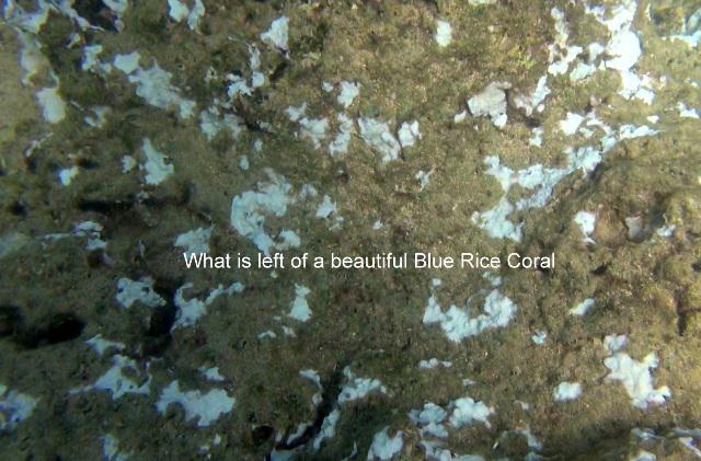
Normally a healthy rice coral is one continuous patch
In considering environmental stressors one must consider ocean acidification and climate change. Runoff from the Hanalei River should also be considered. Over fishing or tourism/sun tan location & boating should also be considered as environmental stressors. Due to the location of the North Shore of Kauai to the Pacific Sands Missile Range, one should also consider its potential effects
Ocean Acidification
Based upon the fact that the corals within 25 yards of each other at Ke’e beach go from 0% disease along the sheltered West end to 100 % widespread disease on the exposed inner reef, I believe ocean acidification effects can be ruled out. The West side of the Big Island also has very little coral disease and ocean acidification in general should be widespread and relatively consistent along coastlines.
Climate Change
Based upon the fact that the corals within 25 yards of each other at Ke’e beach go from 0% disease along the sheltered West end to 100 % widespread disease on the exposed inner reef, I believe climate change can be ruled out. The West side of the Big Island also has very little coral disease and climate change effects in general would be widespread. Also, the Earth has warmed very little in the last decade and most of the North Shore Kauai disease has occurred in the last 3 years according to Terry Lilley.
Hanalei River Runoff
 As I have been involved with over 20 years of environmental impact projects, mostly in the Southeastern United States and I have reviewed the chemical analysis of the Hanalei River discharge, I do not believe the discharge can explain the significant disease and dissolution/disassociation of the coral reef structure along the North Shore. While the mud and low level pesticides might effect a small area at the mouth of the river, mostly through disease, the concentrations are too low to affect to rest of the North Shore to the extreme level of disease and disassociation of calcium carbonate apparent. I believe the Hanalei river can be ruled out as a primary source of problem along the North Shore.
Tourism/Overfishing
Ke’e and Tunnels beaches do not have large crowds of tourists due to restriced parking access and the remote locations. Sun Tan Lotion typically floats on the surface of the ocean and would quickly biodegrade and would not dissolve calcium carbonate. I saw no fishing boats along the North Shore so that can be ruled out. Most of the boating, other than right in Hanalei Bay appears very light and appears to stay ½ mile or more offshore and marine fuel would not affect the inner reef and dissolve calcium carbonate.
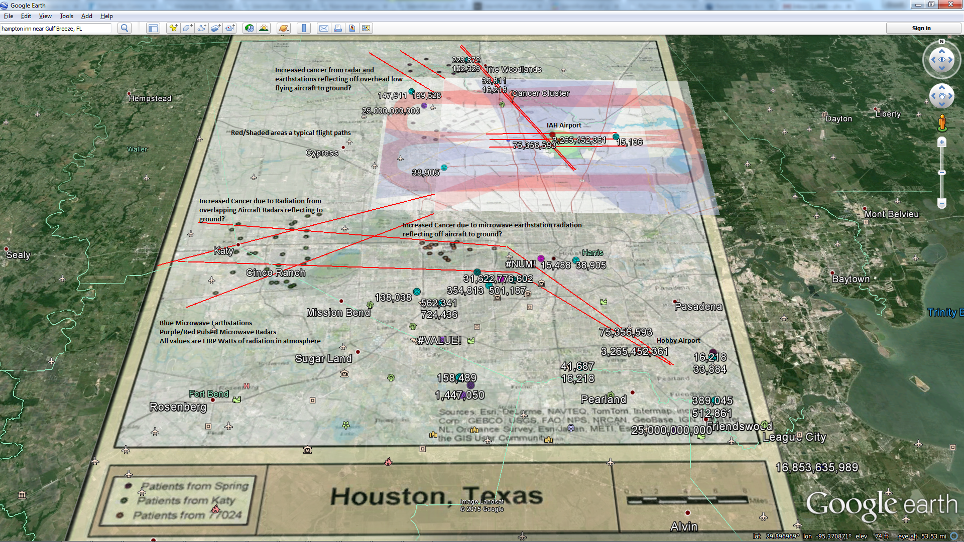
Pacific Missile Range Facility Pulsed Microwave Radars
 This military base is known to pulse approximately 30,000,000 watts of microwave radiation in the 2-6 GHz range using approximately 20 high powered radar stations pulsing at low frequency rates (200-1000 Hz). Multiple radar upgrades over the last decade have approximately doubled the amount of electromagnetic radiation emanating from the radar station. Some of these radar units are rotating high gain military tracking radars and some are phased array radars. It is well known science that the frequency ranges in use can be scattered, ducted and refracted by the atmosphere, more so during storms and inversions/cloudy/foggy conditions. That is why the radars are also used for weather surveillance by NOAA and the military. The mountain peaks over Kauai are also often cloudy, increasing normal scattering in the vicinity of the radar stations. The atmosphere Doppler frequency shifts and attenuates the radiation as it undergoes Rayleigh scattering. The diffuse scattered electromagnetic microwave radiation will behave similar to light in that it will reflect, absorb and scatter of trees, mountains, ocean and all biology, considered biological contaminants. Shaded areas from diffuse sunlight should also get less diffuse microwave radiation. In other words, microwave radiation levels should change just the way your cell phone goes from 1 bar to 5 bars as you walk around.
 Since a typical cell tower might radiate 50,000 watts, Kauai has the equivalent of approximately 600 cell towers atop the mountain on the Northwest of Kauai when the radars are pulsing. Approximately 90% of the recently peer reviewed research on 2-6 GHz radiation shows detrimental effects on biology as well as low frequency pulse effects on Calcium compounds. Very little (<1%) of the radiation emitted from a radar station makes it back to the radar dish, the rest is scattered and absorbed in the surroundings. Due to the high gains (focus) of the military and weather radars, many have effective radiated powers in the Gigawatts. For example, the peak power of the NEXRAD weather radar at Port Allen is 1 Megawatt (1x10e6 Watts) and it employs a directional antenna with a mainbeam gain of 45 dBi; resulting in a transmitted signal power level of 32 Gigawatts.
Seawater is highly conductive and highly grounded to the Earth. Many coastal antennas run their ground into the ocean to get a good stable Earth ground. The US Navy has a patent on using seawater of differing heights as both a transmitting and receiving antenna of microwave radiation. For 2-6 GHz radiation emitted from radars, 1”-4” ocean wave height makes a great antenna. Another US patent shows that electromagnetic radiation conducts and discharges very well in seawater with strong effects within 2 meters (~ 6.5’) and detectable within 70 feet.
 Military radars pulse between 200 and 1000 pulses per second (200-1000 Hz). Low frequency pulsed electromagnetic radiation is well known to disassociate calcium carbonate within saltwater and other water with dissolved ions, “conditioning” or “softening” the water. Industrial products are available on the market as well as commercial on Amazon.com. The US Department of Energy also supports using low frequency pulsed electromagnetic radiation to dissolve calcium carbonate scale buildup inside of industrial boiler tubes to save on chemicals
A basic antenna power calculation shows that during storms and heavy reflection and/or ducting events, the peak pulsed power levels at the surface of the ocean on the North Shore could easily exceed 100 ‘s of watts per sq. meter from the radar stations  atop the hill on North Kauai. The FCC guideline covering radar safety is an average continuous power of less than 10 watts per sq. meter and applies only to absorption and overheating.
Electromagnetic radiation is well known to induce skin effects as the quickly oscillating magnetic fields can induce electrical discharge along the surface of anything exposed. Since increased tumors are appearing in fish on the North shore as well as dead sea life such as sharks and whales, much of this could be due to electrical discharge from the strong pulsing electromagnetic fields discharging into the shallow ocean water around the radar stations. A similar situation is occurring around the 17 pulsed radars near the Indian River Lagoon in Florida.
Conclusions & Recommendations
 Based upon my two years of study of high powered pulsed microwave radar stations and the effects of non-ionizing radiation, as well as 28 years of process and environmental experience and the study of related problems with wildlife in the Indian River Lagoon, FL, Guam, White Sands Missile Range, NM and the North Shore of Kauai, I believe the North Shore of Kauai coral reef is decaying primarily due to a high flux of scattered, pulsed microwave radiation, which will be bad for all biology in the area. I recommend a scientific study should commence immediately by the government, military and private entities to falsify my conclusions. If it is the pulsed microwave radar stations they should be moved away from civilian populations and coastlines immediately.
I have done this research on my personal time and it is not influenced or commercially supported by any of the companies I have been employed with below nor is it supported or commercially influenced by the Reef Madness team.
Special thanks to Terry Lilley for his extensive knowledge of the Reef and keeping me out of trouble while snorkeling in high currents along the shore.
Respectfully
Stewart D. Simonson
Senior Chemical Engineer & Project Manager
B.S. Chemical Engineering, 1986 University of Maine, Orono, High Distinction and High Honors.
Thesis: Interactive Real-Time Process Simulation
1986-1991 Measurex Systems Cupertino, CA: Computer Controls, Sensors (Radiation, Optical, and other)
1991-1999 Sandwell Engineering Consultants, Vancouver, B.C., Atlanta, GA
2000-2004 Harris Group Engineering Consultants, Seattle, WA and Atlanta, GA
2004-2013 Hallmark Engineering Consultants, Atlanta, GA
2013-2014 Large International Engineering Consulting Firm, Power & Process, Earth & Environmental, Atlanta, GA

I am out here trying to help liberate the free world from itself…


