
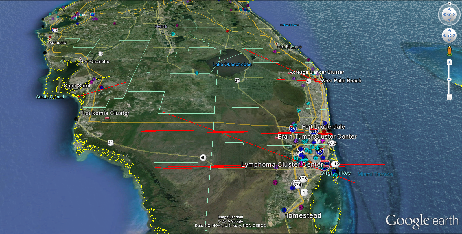
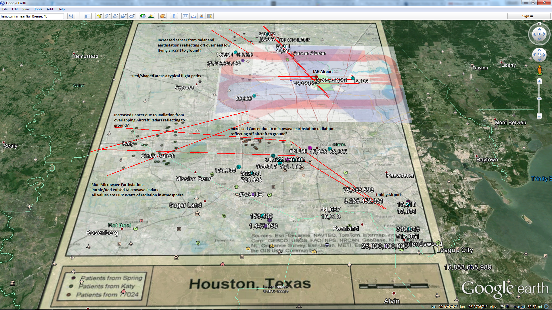
Red Lines Are Airplane Flight Paths. Light Blue Circles Earthstations. Red/Purple Circles FAA/Military Radar. Dark Blue Weather Radar. All generate high power, high gain radiation
Conclusion: Increase in cancer proportional to amount of High Gain, High Power Focused Radiation (High EIRP) from radars and earthstation dish antennas + airplanes to reflect radiation back to surroundings plus lots of weather to scatter/refract radiation back to the surroundings. Similar relationship for autism.. I think the electromagnetic radiation is killing our coral reefs along the coastlines through electromagnetic inductance as well as damaging citrus trees, releasing volatiles and attracting BUGS.
Cancer Cluster Information:
Raid Amin, Michael Hendryx, Matthew Shull & Alexander Bohnert (2014) A Cluster Analysis of Pediatric Cancer Incidence Rates in Florida: 2000–2010, Statistics and Public Policy, 1:1, 69-77, DOI: 10.1080/2330443X.2014.928245
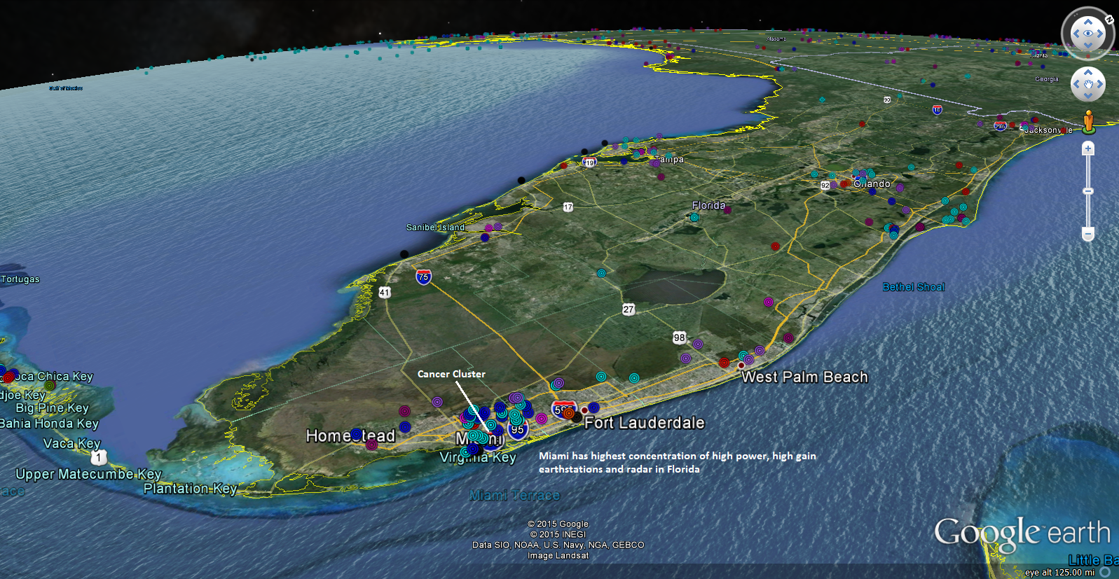
I have added high power, high gain earthstations to my database from the FCC database (Light Blue). I notice that Miami has the highest concentration of these communication stations along with radars in all of Florida. They also have clusters of childhood cancers. I am going to add in a power profile after I fully reconcile power levels . I think all of this high EIRP radiation is reflecting and refracting off the atmosphere (more during storms) and airplanes and gradually damaging biology, one pulse at a time…
Cancer Cluster Information:
Raid Amin, Michael Hendryx, Matthew Shull & Alexander Bohnert (2014) A Cluster Analysis of Pediatric Cancer Incidence Rates in Florida: 2000–2010, Statistics and Public Policy, 1:1, 69-77, DOI: 10.1080/2330443X.2014.928245
http://dx.doi.org/10.1080/2330443X.2014.928245
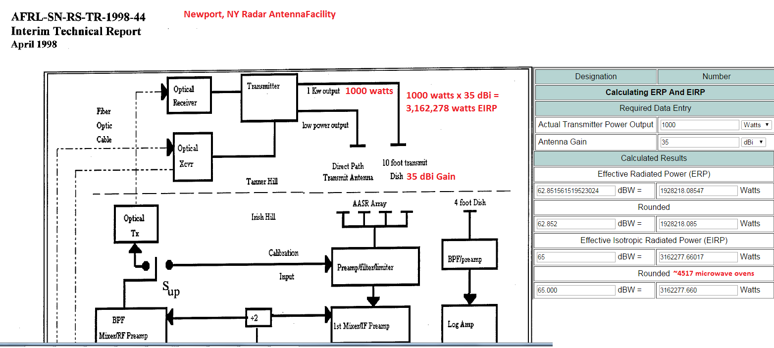
 Most of my readers know I have been trying to help some families in the Newport, NY area get enough information from the military and government to help doctors & scientists evaluate whether the level of radiation emanating intermittently from the Air Force’s Radiation test facility could possibly be contributing to the cluster of childhood cancers and increased disease in the local area around the test station. The colonel in charge said the facilities’ antennas only put out “one watt of radiation” and yet my estimated, first pass calculations show that if the facility were to apply for an FCC licence, they would need to report over 1 billion watts of effective isotropic radiation (EIRP) from the facility (BIG DIFFERENCE) depending upon radar antennas tested.

Unfortunately the US Military and their Military contractors appear to be going the other way by removing the documents I referenced from their servers, some had been online for YEARS!. Luckily, I made a copy of the documents for the mothers and the editors (And You!)
The US Military removed this document:
“This referenced document (www.dtic.mil/dtic/tr/ fulltext/u2/a347013.pdf) states each radar can generate up to 1000 watt (1kW) pulsed power which is then boosted by the 35 dBi antenna to an EIRP of up to 3,162,277 watts each according to my calculations. Multiple that by 5 radars and you can now understand how 15 million watts of pulsed EIRP power can jam civilian airliner GPS systems from hundreds of miles away and also potentially make personnel ill in the surrounding area.”
Here is the missing public document they removed
https://darkmattersalot.com/wp-content/uploads/2015/03/ada347013.pdf

And here is their IP Address
The link to the US government contractor document no longer works (Press Release):
“If the military has been testing up to 30,000-watt AESA electronic warfare radars mounted on the airframes like this article (www.f-16.net/f-35-news-article1250.html) is implying and this one (www.prnews wire.com/news-releases/full-scale-f-35-pole-model-begins-mission-systems-testing-75375517.html) then all bets are off because the EIRP of those units are over 900 million watts of power if you happen to be in the direct/reflected path, which could be very unhealthy over time.”
Here is the missing public document that was removed.

And here is their IP address…
Here is a link to the full article on the Utica Observer-Dispatch
And here is a link to the mother’s petition
And here is a song, have a nice weekend
P.S. Maybe these guys have enough balls to do something…

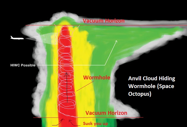
This Wormhole will only transport you 50-60,000 feet but hey, that’s a start! Source: Boeing

Quite a few HF Wave radars and an ARSR-4 radar in Marin County. The side of the mountain that gets more radiation (facing the radars) has the highest rates of breast cancer. Ships passing into San Francisco bay with pulsed radars will also add to the local radiation. Lots of fog in the area can also increase pulsed radiation scattering. Also a couple Dopplers and transmitting station on the SF side of the bay.

Marin County, CA High Breast Cancer Rates. Source:

Similar Map with high Asthma rates. EMF has previously been linked with increased asthma. What is interesting to me is that the smaller, lower gain HF wave radars seem to have a strong impact, similar to my Long Island maps. Maybe that is because the radiation stays closer to the surface, I am not sure.


Holy Shit that’s a lot of focused radiation! Same effect as pissing into the wind according to my research.

Green Icons: Broadcast Networks Transmitter Earthstations, Red Icons: Airport Radars, Blue: Corporate Satellite Earthstations, Grey: HF Wave Radars

I think the hillsides are getting struck with lots of radiation from all of the radar and earthstations, increasing disease rates in the high rent district (higher income, more expensive neighborhoods) on the hillside.
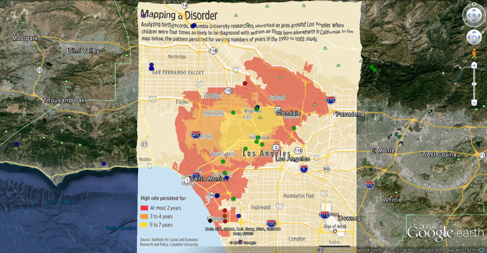
Conclusions of this study: I Love Lucy re-run broadcasts contribute to autism
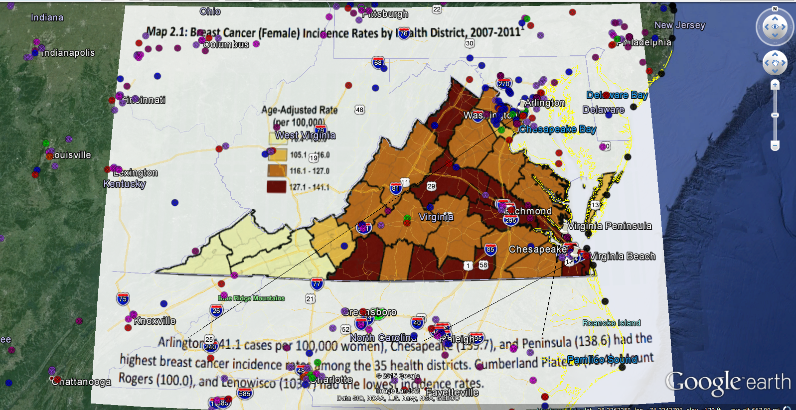
Arlington, VA , Chesapeake, VA and the Virginia Peninsula have the highest rates of breast cancer as well as the highest concentration of installed pulsed microwave radars and Earthstation high-gain satellite communication systems (colored circles). The Virginia peninsula also gets lots of warships and aircraft with radars.
Source: http://www.vdh.virginia.gov/ofhs/prevention/cpc/documents/pdf/Cancer%20in%20Virginia%202014_Final.pdf
I added in Earthstation sites to my database from this source: http://kuhnke-international.com/resources.shtml
I am still reconciling EIRP levels so I am just showing locations and not a power profile.
I am still vacationing in my mind


