

My research tells me there is an increase in “ionized plasma” discharges from the atmosphere to Earth around the perimeter of Doppler Towers, increasing seismic activity, sinkholes, fish kills, algae and poor health in humans.
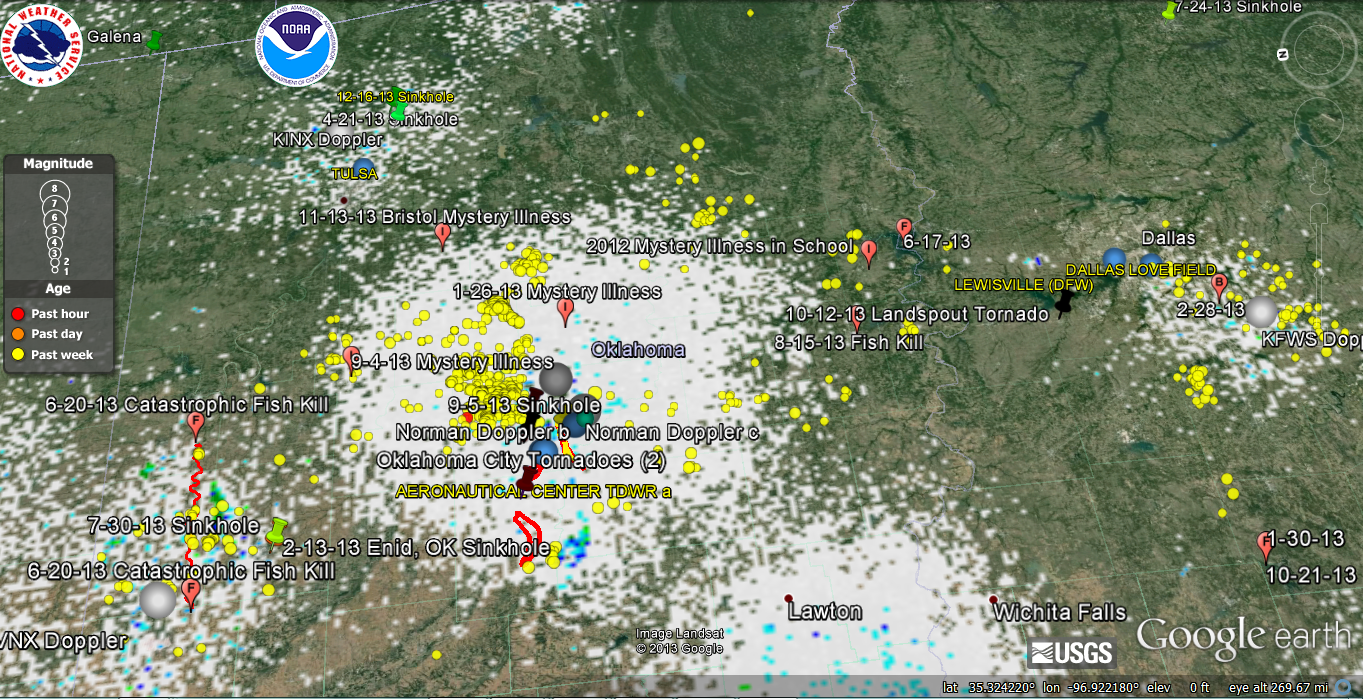
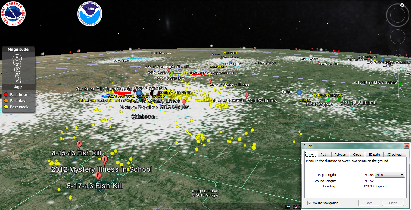
I decided to look at the data for the continuing Earthquakes in/around Oklahoma/North Texas and Arkansas. I drew a box around them in Google Earth and using the USGS site I downloaded all of the Earthquakes (all magnitudes) since 2009 and it returned approx. 1576. There have been over 200 M 3.0 or higher earthquakes in Oklahoma. There is concern that some of these may be induced by fracking, which I really have no opinion on as it may have some effect.
I do notice that the National Weather Service is based near Oklahoma City in Norman, OK. I count at least 6 or 7 Doppler weather radars in/around the area, which is understandable since they have lots of tornadoes and severe weather. I added up all of the Doppler radar stations in North Texas, Oklahoma and Arkansas inside my box and I count 31 Doppler NEXRAD/TDWR Microwave radars.
So I plugged that data into my analysis routine with the following results:
Null Hypothesis: No relationship between Doppler radar locations and seismic activity
Data: 1576 seismic events since 2009 and 31 Doppler radar stations in the box within 31.5-38.2 N Latitude and -88 to -100 W Lon.
There are 7811 instances where seismic events are within 50 miles of a Doppler Station (around Oklahoma city, the highest concentration of seismic activity, many seismic events are withn 50 miles of 5 or 6 Doppler stations). For my 31 random points, there are 1708 instances of towers within 50 miles.
Metric = (7811/31)-(1708/31) =196.9
10,000 iterations, randomly shuffled 62 data points, p-Value = 0.0001
A p-Value means only one thing (although it can be phrased in a few different ways), it is: The probability of getting the results you did (or more extreme results) given that the null hypothesis is true. In other words there is a 1/10,000 chance there is NO relationship between Doppler locations and seismic activty. It does not confirm Doppler causes the earthquakes, it just implies they are related in some way.
BTW, in the same area of the seismic activity, I have recorded multiple fish kills as well as some strange illnesses in towns such as in Bristow, OK. The area around Oklahoma City also happens to be the area of the most damaging tornadoes in 2013, similar to the large number of waterspouts in the Tampa, Fl area which has 2.0 MWs of pulsed Doppler stations. Oklahoma City area must be pulsing 3-5 MW’s into the area based upon all of the Dopplers I count.

I realize all the good that NWS and NOAA bring to the public. But to be honest, I think those Doppler radars are killing people as I write this to you, which is why I am going to keep researching and publishing my data. I have no control over what others choose to do or not do.
Godspeed
I am reposting this blog from a year ago. Man, how time, if it existed, flies.
Imagination will often carry us to worlds that never were. But without it we go nowhere.
Carl Sagan
It actually happened to me when I was a kid. One of those Snowmageddons, Snowpocalypse or Snowzillas around 1970 struck Maine and it snowed for 3 days. On Christmas morning there was a note on the tree from Santa telling us that he had to leave the presents at our grandparents place in town due to sleigh failure caused from the storm. Dad called a friend on Christmas morning with a 4-wheel drive Jeep with chains on the tires and he delivered the gifts to the end of our 100 yard driveway. My dad made a few round trips with snowshoes and a toboggan to get the gifts. Happy kids, thanks dad.
Now that I have grown, matured and see the world as it should be through these new strangely bizarre dark matter glasses I now probably understand what really happened, although I think I like the kid image better:

Sort of like the new Dreamliner…
Due to climate change, the moisture in the atmosphere was higher than normal and the oceans a bit warmer to fuel a winter storm. But that by itself was not enough. It took a recent period of increased solar activity to pelt the earth with a dose of massive entropic dark matter particles weighing maybe 1E15 kg +/- but only 1500 fermis in radius. The particles entered the Earth probably within a few miles of the farmhouse in Maine (the sinkhole created over 6 weeks of orbiting was not discovered until the next Spring planting season), orbited through the earth and popped back out, probably in Europe or the Atlantic Ocean somewhere. The particles formed strings in the atmosphere and telluric currents through the Earth. As they orbited through the atmosphere they ionized, condsensed and collapsed the gas in its surroundings and formed closed strings of dark/vacuum energy. They continued to do that for the next few weeks while their orbit slowly decayed through quantum decoherence and the low pressure system that formed where the particles were exiting the earth continued to gather and condense moisture and create one hell of a storm and low pressure system within their surroundings. Read more…
That reminds me of some other fairy tales such as:
The mad cow jumped over the moon
Little bow peep has lost her sheep to chronic wasting disease
Jack and Jill had autism and wandered down the hill
Humpty Dumpty sat on a wall that crashed into a sinkhole
While Finding Nemo his reef bleached and he deceased
Twinkle twinkle little star fish wasting disease
The bats in the belfry died of white nose syndrome
Rudolph the red-nosed reindeer drowned in the melting North pole
Winnie the Pooh died of malnutrition because the bees disappeared due to colony collapse disorder
I am sure I can think of a few more.
Godspeed
 I stayed up late last night, I have finally finished my Google Earth plotting/statistics program to crunch the data I have been manually plotting for the past year from news articles and some of the State databases. I had to learn Python, a programming language, which was not too hard since I already know some C++ and Visual Basic. It must be a female language because it forces me to do a lot of things I don’t want to do, like having my columns lined up just right, it is case sensitive and uses “tuples”. I thought a tuple was something wives sold at one of those house parties? And then there was the Google Earth Geocoder that you send an address into the Google ether and it returns longitude and latitude. It must also be female because it complains a lot back to me and it also cuts me off from having too much fun, after 2000 submissions…
Anyway, I also had to learn about p-values, which are used a lot in biology/science to help determine if something is significant and/or related. I am not going to go into the significance of that but you can read it here. I have done a lot of hyphothesizing on this blogsearch site for the past year, attempting to turn my hypothesis into a theory and then prove the theory myself, because, quite honestly it is so outlandish and bass-ackwards to the way we normally think about our surroundings that I felt the need, had some spare time and it keeps me out of trouble at night.
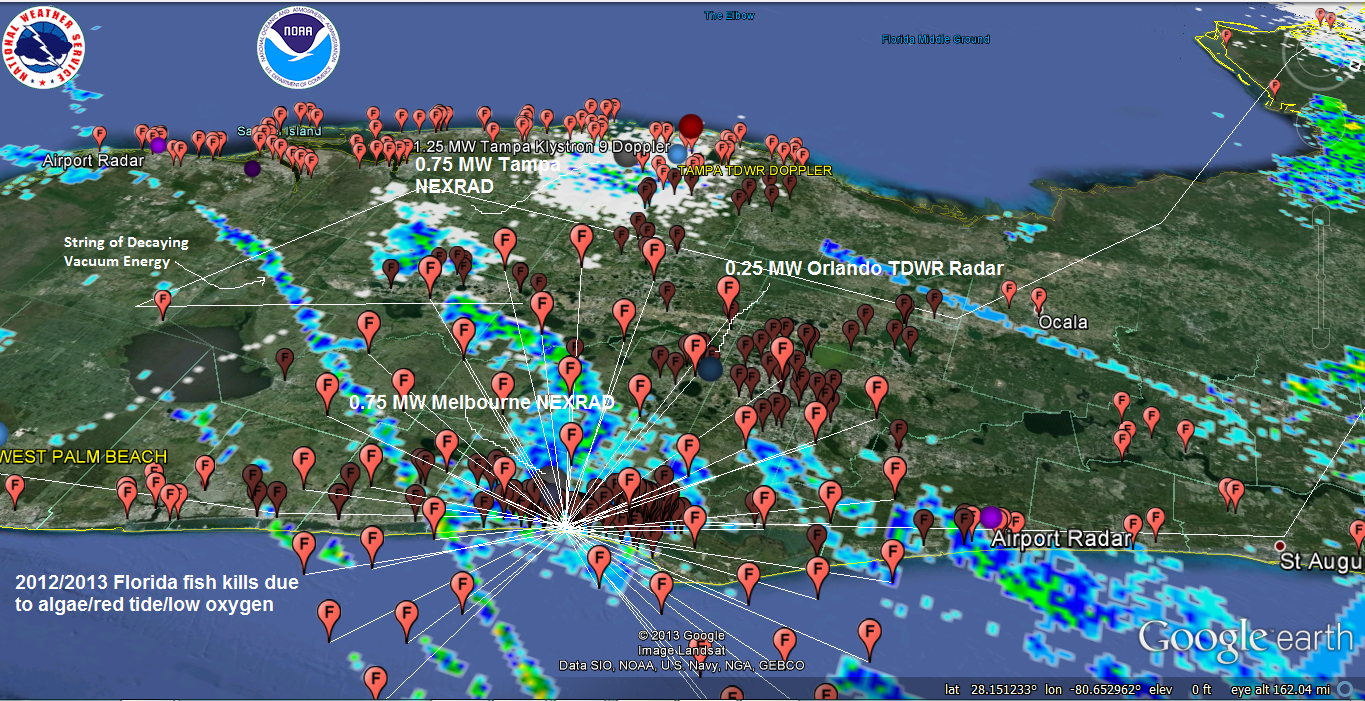
So here are the VERY preliminary results for Florida:
Data Set: 2012/2013 Florida fish kills associated with Red Tide/Algae/Low Oxygen
Null Hypothesis: “No association between Doppler radar locations (14) in Florida and Fish Kills Associated with algae blooms/red tide/low oxygen from 2012/2013”
Data: 2287 Instances of fish kills associated with red tide/algae/low oxygen within 50 miles of a Doppler radar tower vs. 893 fish kills within 50 miles of 14 random locations within Florida (Random coastal polyline since most radars in Florida are along the coast). Some fish kills are within 50 miles of multiple radar towers or a random site so I counted each as an instance.
Metric = (2287/14)-(893/14) = 99.57
Analysis Results: 10,000 iterations by shuffling 14 sets of random tower location with 14 actual tower locations (longitude & latitude) yielded 16 instances of a higher metric.
p-Value: 0.0016
I understand that p-values less than 0.01 can be significant.
I don’t sit here today and tell you that I am correct about the relationship, BUT EVERYONE SHOULD CHECK FOR THEMSELVES, THE SOONER THE BETTER since the hair is standing up on the back of my neck.
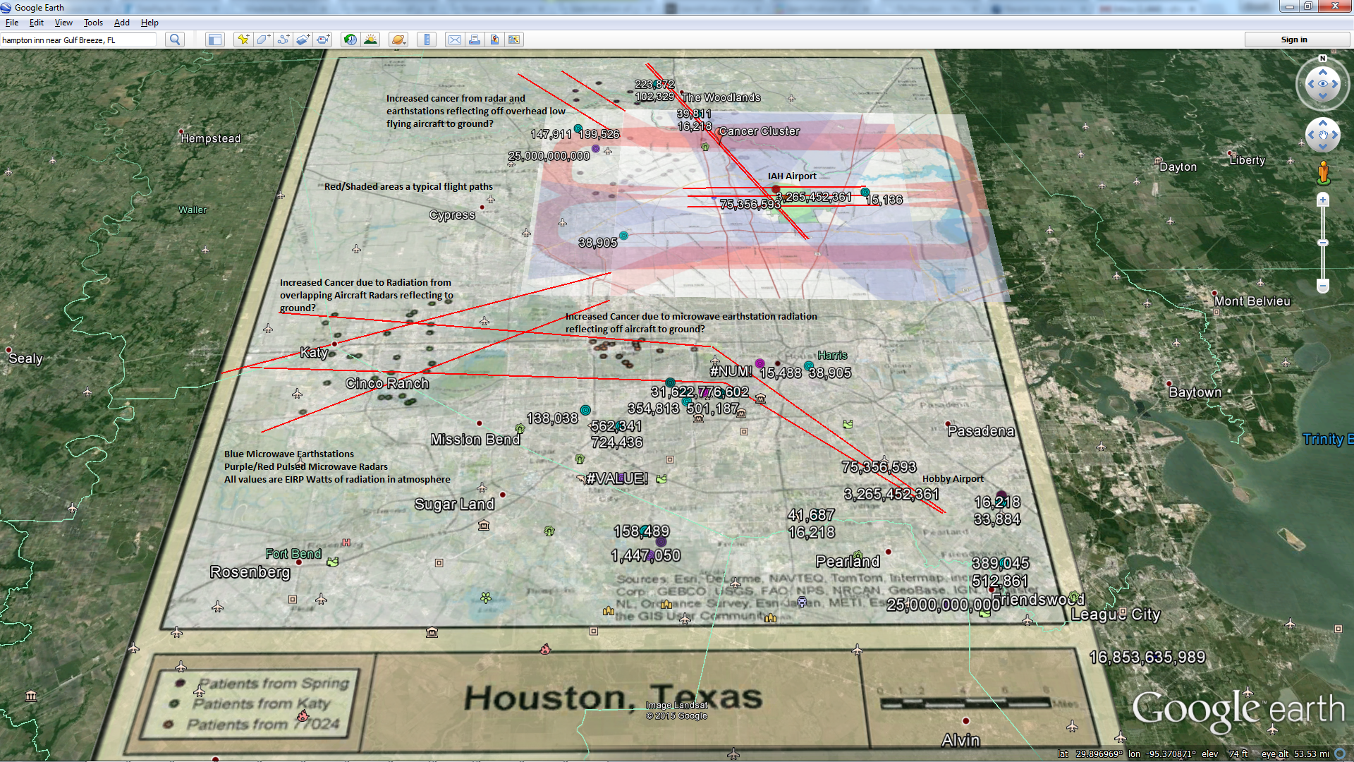
THE KILLERS
FAA Long Range RADAR Site
Melbourne FAA Long Range Radar Site
Latitude: 28.076389
Longitude: -80.506111
Exclusion Zone: 10 nautical miles
250,000 Watts Power
NEXRAD KMLB – MELBOURNE, FL
750,000 Watt Pulsed Microwave Radar
J-05A
Callsign: J-05A
Melbourne, Florida, USA
ARSR-4
USAF: Eastern Air Defense Sector RADAR
FAA: ASO Southern
Power:60,000 watts
Total Pulsed Microwave Power over Melbourne area 24/7: 1,060,00 Watts
Holy Night.
Unlike man-made fission and fusion, nature can release gigatons of energy without completely irradiating and destroying the surroundings. You can thank quantum gravity for that. We should all get us some. At first it will be like wrestling a greased pig
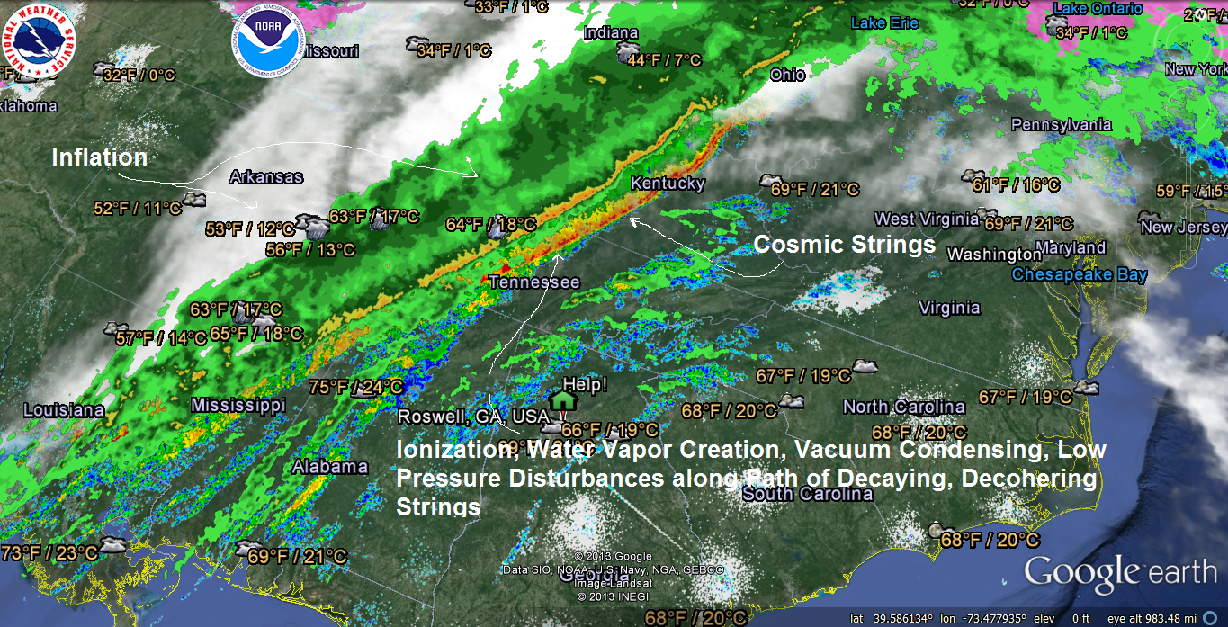
 It looks like it will hit our area early tomorrow morning. You have to be impressed by the force of nature that can already kick up 40 mile an hour winds while it is still 300 miles away. THAT IS VACUUM ENERGY. My research tells me those decaying strings of vacuum energy were curled up by the Sun and possibly Comet ISON. Our quantum God does not just bring the rain, it creates it.
Batten down the hatches, we are in for a blow.

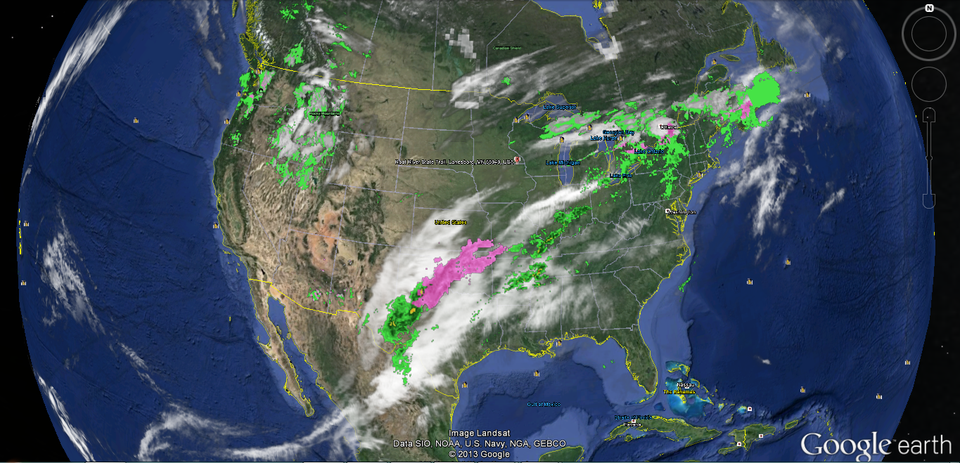 Expect increased uncertainty along the path of those entangled “cosmic” strings as they sweep across the US and gradually decay space around them. Increased ionization, condensing, electromagnetic discharge, mesovortexes, super cell storms from decaying, broken off kinked up strings, high winds, sinkholes and an overall increase in entropy from quantum decoherence along their path as well as an increased beckoning to “Mother Nature” and Acts of God” as humans try to explain it all.
Those cosmic strings will also twist, reflect and attenuate Doppler microwave radiation in all directions, including the ground, creating “anomalous signals” as they pass by those towers, generally increasing penetrating weakly ionization radiation to you and your family. BTW, anomalous is a scientific way of saying “what the F*&$ was that” and still make you feel like the physicists and electrical engineers actually knew what was happening and that they have a F*&#ing clue where all of that 750,000+ watts of pulsed Doppler radiation is going 24/7 or what it might be doing to you and your family and nature in general.
Godspeed
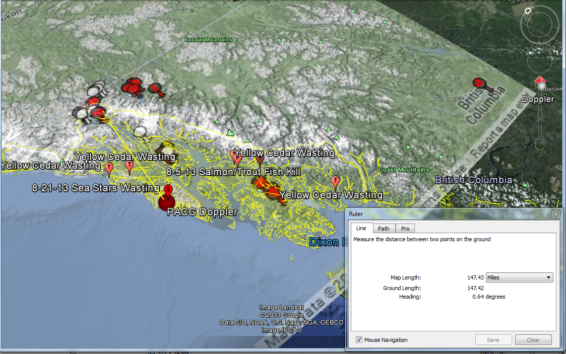
Sea Star Wasting, Amphibians Dying, Yellow Cedar Wasting, Salmon Fish Kills, within 160 miles of Sitka, Alaska 750,000 Watt Doppler Radar Station
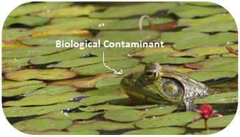
Non-precipitating echoes may be due to artifacts such as anamalous propagation, ground clutter, electronic interference, sun strobe, and biological contaminants (i.e., birds, bats and insects). The local texture of reflectivity fields suffices to remove most artifacts, except for biological echoes. Biological echoes, also called ”bloom” echoes because of their circular shape and expanding size during the night time, have proven difficult to remove,
Don’t worry, if we wait long enough we will have removed them
Godspeed


